

Pomperaug Trail-Adventure Challenge
Trail 2 Trail Series
2017 The Pomperaug Trail-Adventure Challenge

September 17, 2017
START TIME: 9:00 AM
Check in time 8:30A
REGISTRATION
We welcome the Pomperaug Trail-AdventureChallenge.
The Pomperaug Trail in Southbury and Oxford primarily parallels the Housatonic River (Lake Zoar) on the high western bank and ridge running south to north.
Some sections of rugged and moderate difficultly.
This is a single track out and back starting at Kettletown State Park following south on the Pomperaug blue blazed trail through Jackson Cove and turn around at Fiddlehead Road in Oxford.
It is a beautiful trail, many parts challenging that you ‘won’t forget it’.
The start finish will have food/snacks, water. There will be a water station (and some snacks) at Jacksons Cove and at the turnaround. (approx every 3 miles).
There are 12+ miles in this event. One who signs up should have some experience with trail running and should have atleast finished equivaluent to a trail 20k or 1/2 marathon. One must be able to follow blue-blazed markings since there will be limited T2T markings during this event.
This should be a great fall trail run.
See you on the trail.
Come and join all your fellow trail-runners for camaraderie and great trail run. A race to enjoy.
This is the fourth year as Trail 2 Trail Series. Most of our events are based at state parks. We continue to search and explore many trails in anticipation of future events.
REGISTRATION:
POMPERAUG TRAIL-ADVENTURE CHALLENGE REGISTRATION
RACE DESCRIPTION:

The race Starts at Kettletown State Park at the beach area. Park just before the beach at Kettletown State Park. We will start at the same place we have our annual Kettletown State Park Challenge Race every May. When you are at the beach, walk past the bathrooms and you will see us there.
The park opens at 8am. We will start setting up at that time. Please check starting at 8:30am. Race starts at 9am. We typically end up starting the race approximately 10 minutes past the stated time, to allow those who are running late, so no need to rush.
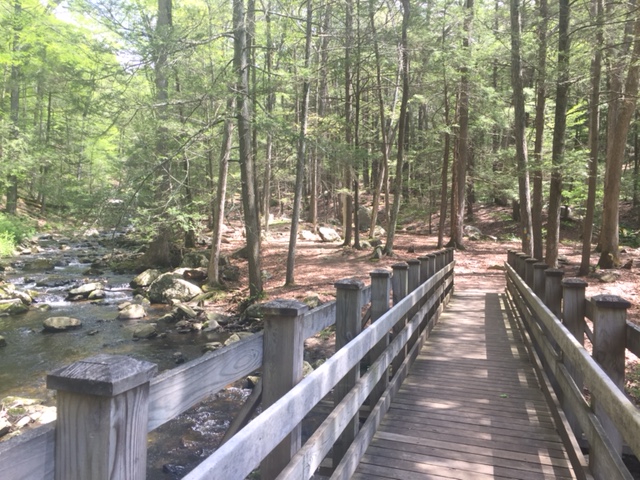
This race will start off like the Kettletown State Park Challenge where the start is at the beach area, and heads north-east starting across a bridge and following the Blue-Yellow blazes. This trail will eventually lead to the Pomperaug, blue blazed trail. Once you cross the wooden bridge, take a left to follow the Blue-Yellow blazed trail which parallels a stream (on your left going out). The Blue-Yellow blazed trail will end at a road that you will cross. Once crossed, you are on the Pomperaug Blue Blazed trail.
Kettletown State Park Map:
http://www.ct.gov/deep/lib/deep/stateparks/maps/kettletowngps.pdf
The Pomperaug Trail is relatively easy to follow. It is recommended that you have a basic understanding how to follow trail Blazed markings since we don’t expect to add any additional markings. We may have some “confidence” markings (orange ribbons) along the trail at certain points to help guide your way. Don’t rely too much on these ribbons since they will be used sparingly on the trail to help you identify the blue blazed trail. The existing Blue blazes are easily identifiable and are well seen throughout the trail.

Once you start on the Blue Blazed Pomperaug trail, stay on it until you reach the turn around point at Fiddlehead road. There will be other blazed trails out there; avoid following those trails since you will be off course. The Pomperaug will follow Southward to Fiddle head road going out and Northward after the turn around heading back.
[For those who raced in the Kettletown State Park Challenge in May, you will notice that we will be traveling backward on our course as you go out (which is part of the south counterclockwise loop at the Kettletown State Park Challenge in May)]
The first part of the Pomperaug (0.55 miles) you will pass the crest trail (Blue-White blazes), pass the Camp ground trail (Blue-Red blazes). Passed the Camp ground trail (Blue-Red blazes) you will follow (0.81 miles) up toward some rocky terrain, where you may feel like you have to scale up and down them. Eventually you will come up to another sign; continue to follow on the Pomperaug trail to Jackson Cove. Here you will travel downhill to Jackson Cove, which is where we will have am aid station before you continue into the woods.

After Jackson cove, you continue on the Pomperaug trail; in approximately 0.10 miles will meet up with another sign which will point the way to the Pomperaug trail.

Stay on the Pomperaug and follow this up and down some cool narrow terrain that crosses a stream (a tree is conveniently laid across for your travels) and then continues up and down on some well maintained trails. This area has a mixture of trails where you can coast, with some challenges in between. I can say it is one of my favorite section of trails. There are many narrow paths and rocks need to climb over and around that will make you glad you have continued this far. You will eventually end up at Fiddlehead road; the is the turn around point; congratulations you made it this far. You may have a slight saddened thought that this is the end of the trail, but then will feel happy that you will do it all over again in reverse. We will have an aid station and a staff member taking down your bib number at Fiddlehead road. Please make sure your bib number is recorded, otherwise you will be considered DNF (did not finish).
Fiddlehead Road Trail head sign:

Return back from Fiddlehead road in reverse. Paying mind to stay on the Blue Blazed Pomperaug trail. Continuing to the north end of the Pomperaug, crossing the park road and following back on the Blue-Yellow blazed, Southwestward where the stream will be on your right; cross the bridge and there is the finish. Make sure we record your bib at the finish.
We always encourage to bring a cell phone with you in order to have the trail information on and just in case of an emergency. If you find that you are having a problem and/or unable to continue racing the event, try to make it to back to once of the aid stations. We can arrange to pick you up to bring you back to the start.
RACE RULES
The race rules include but are not limited to the following:
1) Stay on the trail. Stay on the designated marked route. The course will be well marked with flags and marking tape. Some of the trails will go through protected wildlife areas and we do ask that you stay on the trail to avoid harming these sensitive areas.
2) Be courteous to other trail runners and hikers on the trail. -be patient when you are part of a conga line on crowded racing trails. -Slow runners yield to faster runners. -If you would like to pass a runner, give a courteous and audible announcement well in advance of your presence and intention to pass stating something like “on your left” or “trail” as you approach the trail users. -Show respect when passing, by slowing down or stopping if necessary to prevent accidental contact. -Be ready to yield to all other trail users (bikers, hikers, horses, ect.) even if you have the posted right of way. -Uphill runners yield to downhill runners in most situations.
3) Don’t Litter -Runners are encouraged to bring a hydration bag, belt, or bottle. – Disposable cups will be available at each aide station. Kindly dispose of the cup in the trash bins at the aide station before proceeding on your run. -Pack out everything you started the race with. Food leftovers should not be thrown on the course, they should be kept with the runner until they reach the next aide station, disposal area, or finish line.
4) Safety – be familiar with your route. You are expected to negotiate many rocks, roots, hills, possibly some climbs and get your feet wet. The technical nature of the trail will mean that you will be exposed to the risk of injury. All participants must be prepared to accept full responsibility for these risks. – be prepared for the weather and conditions prevailing – No headphones or iPods. – Know and respect your limits. – Each runner is strongly advised to carry a fully charged cell phone with the race director’s number, a fellow runner number, or some other contact that may be at the race venue for safety and emergency use. -If part of the route crosses a road, you are to yield to any vehicles before proceeding to cross the road. -No crew/pacers/spectators on the route. Crew or spectators are allowed at designated areas.
5) Leave what you find -Leave natural or historic objects as you find them, this includes wildflowers and native grasses. -Removing or collecting trail markers is serious vandalism that puts others at risk.
6) Bandit Runners -Trail 2 Trail Series does not condone bandit runners. Not only are bandits a serious safety and liability concern for the race directors. There are limits in the races set forth by permit. Bandits can jeopardize the issuance of future permits. -Participants are not allowed to run with dog(s) during the event.
Trail 2 Trail Series requires participants to follow all race rules.
Those who do not follow the rules are at risk for disqualification.
What if I am dropping out?
If you are dropping out before distance you are registered for, you must let the Trail 2 Trail series staff members know you have dropped out from your registered distance. This will help to avoid an unnecessary search party and to confirm that you would like to be listed under a different race category if you finished at least one loop.
Those who have not finished their registered distance will be given a designation on the race results as DNF (“Did Not Finish).

START TIME AND LOCATION:
Start Time and Location:
start time: 9:00 AM
The race will begin at Kettletown State Park Beach area. You will find staff and the check in tent.
Start/Finish area:
1400 George’s Hill Road
Southbury
Off Interstate 84: take Exit 15. Go south onto CT Route 67. Take a right at the first traffic light if coming from the west, and a right at the second traffic light if coming from the east, onto Kettletown Road. Continue for approximately 3 miles on Kettletown Road. Take a right onto Georges Hill Road. Park is located on the left approximately 0.6 miles.
Aid Station #1:

VOLUNTEERS:
Please thank all the volunteers. They are taking their time out to help make your experience a safe and enjoyable one.
If interested in volunteering please register to volunteer at this link:
Any who volunteer is granted credit toward future races.
CHECK IN:
Check-in will begin at 8:30 AM (0830). This will be at the Start/Finish area.
Please Know your bib# ahead of time to streamline the check-in process:
(bib numbers will be updated days before the race. Please follow the link to look for your bib number. We will have a list in alphabetical order on race day).
START AND CUT-OFF TIMES
The start will be 9:00 AM (0900).
The cut off time for all races is at 12:30 PM (this gives you 3.5 hours to complete your race).
Race Day Registration:
We encourage registration via on-line. If for some reason you were unable to register on-line, we will only accept checks (made out to Trail 2 Trail Racing LLC). Cash exchange is otherwise not allowed on the premise. We have extended the online registration end time to try to include those who are late participant registrants. It does help the race directors and staff greatly if you register early, since their is a lot of last minute logistics that go on within the last few days before race day.
FUEL AND AID STATIONS
There will be 3 Aid stations. One at the Start/Finish, at ~3mi, and 6mi out. You will return back passing the mile 3 Aid Station.
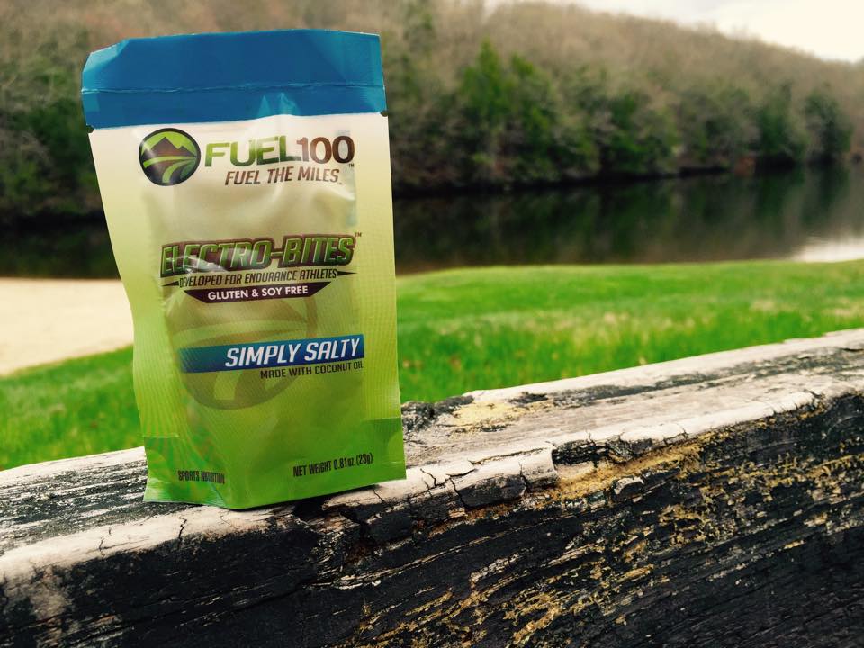
The main aid station will consist of the following: Water, Fuel 100 Electro-Bites, Bananas and Oranges, HEED electrolyte drink, and Endurolyte supplements. Their will be another unmanned aid station that will consist of water. We encourage that you bring a handheld water bottle, or the like, to keep it ‘green’, although cups will be available.

TRAIL MARKINGS
You will follow the existing Blazed Trail. You must have basic trail knowledge in order to follow the blazed trail systems. Leaving the Start (at the beach), you will follow a short white blazed section of trail that starts you across a wooded bridge. You take a left after the bridge continuing to follow the white blazes adjacent to a stream which will be on your left going out. This will lead into the Blue Blazed trail system: the Pomparaug Trail (Blue Blazed trail). You will follow the Pomperaug till the turn around point, following back on the Pomperaug which will lead back to the short white blazed trail (stream now on your right) following across the wooded bridge to the beach -> the start/finish location.
SWAG:
Each participant will receive a special custom T2T series beanie.
SPONSORS and PARTNERS:


http://www.trail2trailseries.com
http://www.twitter.com/trail2trail
Trail 2 Trail Racing LLC
Categories
